Artlantic City?

IMG_5195
[CHANGING? ROBERT BARRY’S ILLUMINATED TEXTUAL PIECES]

Above is an element of “Wonder”, an outdoor art installation part of Atlantic City’s Artlantica massive project to distribute $12 million in public art throughout the beleaguered city over the next five years. Located at Pacific and Indiana on the seven acre lot formerly occupied by the Traymore Hotel and the Sands Casino, the grassy, half moon berms form a cove of refuge from the schlock and gall of Pacific Avenue.  Organized by international curator Lance Fung, Artlantic has befuddled the art world and the average Atlantic Citian with its scale dwarfed only by the mighty hopes it will inspire an American Venice.  Largely a project of the non-profit Atlantic City Alliance and the Casino Reinvestment Development Authority, Artlantic is seen as an effort to diversify the city’s portfolio of tourist attractions (while providing some ephemeral construction jobs over time).

Atlantic_City_Hotel_Traymore_Block_Illinois_1900
[ATLANTIC CITY, 1900, SHOWING TRAYMORE PARCEL AT PACIFIC AND INDIANA: COURTESY OF RUTGERS]

Whether its simply economic development shillery or a real vehicle for getting the non-high rollers to AC is unclear.  Increasingly the arts and culture sector is seen as having real generative power; the question is whether it can be seeded in a place ravaged by capital’s many recent crises.

IMG_5212
[WONDER LOOKING WEST TOWARDS ILYA AND EMILIA KABAKOV’S PIRATE SHIP]

IMG_5203[KABAKOV’S SHIP]

A tour of the northern part of the island, in the neighborhood called South Inlet reveals a singularly unique state of urban America.  An almost narcotic reliance on gaming revenue has oriented nearly the entire urban land market towards casino construction. But, land is too cheap in AC and returns on investments in massive assemblages of parcels are meager.  Thus, Revel sat as a ruin-in-wait for nearly 3 years before the numbers looked good enough on paper to complete the project.  Revel’s downward trajectory means a the parcel at Pacific and Indiana will likely remain a public art park.

owner-type2
[OWNERSHIP OF VACANT PARCELS IN AC, COURTESY OF JASON HANUSEY]

Because this regrouping of capital can be slow, Atlantic City is a place of startling contrasts in building scale.  Both 1960s-1970s casino-oriented zoning policies and casino construction trends have made speculatory land buying and absentee ownership rampant in Atlantic City.  Thus according to urban planner Jason Hanusey, nearly 20.4 percent of all developable parcels in Atlantic City are vacant.

Atlantic City was once a real city of density, intimacy and structural variety.  As the general resort trade dwindled in the postwar era and gambling became legalized in 1977, vast numbers of vacant or underutilized parcels—some irregularly following railroad rights-of-way or the contours of multi-winged hotels—were melded into regular megablocks.  Gone was the intimate scale of the brick and wood rooming house or the small porch-swathed hotel.  This process continues as the Casino Reinvestment Development Authority (CRDA) targets the desolate South Inlet section for massive investment.  “We want to create a neighborhood here,” Executive Director John Palmieri said. “It’s no mystery. It’s a beautiful location.”  Yet what kind of neighborhood can exist around a planned $75 million entertainment complex, arguably the anchor of CRDA’s new South Inlet?

IMG_5219
[SOUTH INLET SECTION, JULY 2013]

Atlantic City, one could argue, is a city without people.  It is a largely binary system of producers and consumers  enclosed and insulated from the public sphere. Plans for arts, tourism, shopping districts and the new South Inlet need to reverse the trend of a spatially segregated series of activity centers all with their back to the public realm.  Good urban design taking cues from unique AC forms, a creative mix of housing for all income levels, open space which augments natural processes and, dare I say, new populations will create places where economic and social interaction can occur outside Caesar’s.  This is a prescription not just for humane treatment of dispossessed residents but also a formula for a more complex economic system of neighborhood suppliers and producers.  Here is where Artlantic can assist.  The project should encourage artists to live and create in the community, to channel community interests into public interventions while the Alliance and CRDA should improve physical (i.e. transit) and cooperative links with other art centers (Philly, Asbury Park, NYC) while subsidizing spaces for building and making.  This is true integration of the arts and urban planning—less about art as a destination and more as a mode of living.

IMG_5213

“Recovering together” naturally: the case for natural flood protection in South Jersey’s coastal zones

IMG_4462
[LOOKING ACROSS JETTY AND ABSECON INLET AT ATLANTIC CITY]

Over at Design Observer, the preeminent geographer of New Orleans, Richard Campanella makes a strong plea for a balancing of the nation’s “sediment budget”, an inequality that some of our Jersey shore communities feel most acutely in the wake of Sandy.  As Campanella has pointed out, the anthropogenic changes to our coasts and waterways have laid the foundation for the unprecedented economic growth of the nation:

“We routed water from wet to dry places via aqueducts, canals, pipelines and reservoirs, to be used for hydroelectricity, irrigation, municipal and industrial purposes, and upon these systems we built the world’s largest economy.”

Similarly, Atlantic City’s resort economy is built on a series of man-made infrastructural interventions: from the railroads in the 1850s to jetties and groins to the partially private-funded AC-Brigantine Connector tunnel, Atlantic City survives due to a series of public infrastructural umbilicals.

historical_shoreline_absecon_island
[GROINS HAVE EXTENDED ATLANTIC CITY’S SHORELINE FOR MOST OF THE 20TH CENTURY]

Many of these landbuilding structures currently in use by the US Army Corps along the Jersey Shore–jetties and groins primarily–do little but augment and reinforce natural depositional patterns.  They’ve served to extend Atlantic City’s northern section further into Absecon Inlet although there is not much density occupying this space.  As Campanella has also expertly noted, the successes of large scale landbuilding infrastructure projects often directs development into areas of muted danger.  Only during storms like Katrina and Sandy does the “obscured relevance” of these natural processes become violently apparent.

Though not a levee or a floodwall the 3,727’ Absecon Inlet jetty on the east side of the waterway is a piece of this quietly reassuring infrastructure.  Designed and built in 1948 for what the Army Corps calls “channel control,” the jetty functions by creating a hard edge to capture the fleeing sands of northern Brigantine Island from entering Absecon Inlet and blocking this vital thoroughfare.  Sitting 8’ above the mean high water mark, it’s also a formidable barrier which invited development along Brigantine’s Ocean Drive and Sunset Court.

Jetty_Location
[LOCATION OF ABSECON INLET JETTYS]

Yet during Sandy, the inlet crested both Absecon inlet jetties, flooding Atlantic City and severely scouring and undermining the bulkhead along Ocean Drive.  According to the Atlantic City Press, a beach replenishment project amply protected the Atlantic side of the city, but the inlet and back bay sections were notoriously porous.  The City and the Army Corps will soon open bids for constructing a section of seawall between Oriental and Atlantic Avenues, with another section proposed but neither designed nor funded further north.

31Oct
[NOAA AERIAL IMAGERY SHOWING INLET CRESTING EASTERN JETTY 31 OCTOBER 2012]

IMG_4464
[AFTER CRESTING THE JETTY, THE INLET SCOURED UNDER THE BULKHEAD ALONG OCEAN DRIVE]
IMG_4467
[HOUSES ALONG OCEAN DRIVE SUFFERED TREMENDOUS EROSION]

A near constant commitment to new flood protection infrastructure has a predictable impact on development in both Atlantic City and Brigantine.  Despite the proximate danger of a swollen Inlet, a new residential complex at Rum Point has just broken ground–after extensive litigation with NJ Department of Environmental Protection.  Arguably, the people pay doubly when the Federal government subsidizes risky residential building through infrastructure and generous national flood insurance programs.

Seawall_Construction-002
[PROPOSED SECTIONS OF SEAWALL IN ATLANTIC CITY. MAP BY CHRIS DOUGHERTY]

Yet options do exist for “softer” flood protection.  One of the rare “successes” of Superstorm Sandy was found in Jersey’s protected marshlands.  According to the American Littoral Society’s report on Sandy’s impact on coastal habitats, coastal restoration projects like the south Cape May Meadows (a project developed by the Army Corps, the Nature Conservancy and NJDEP) “fared very well during the storm and achieved its goal of flood protection.”  Salt marshes and dune systems also blunted traumatic storm surges and waves.

The dialogue around the failures of rigid flood control systems and the embrace of more adaptive natural systems is becoming increasingly robust.  Increasingly, cities in littoral areas across the globe have developed fraternities to exchange more natural techniques for combating rising sea levels.  In these dialogues, ‘combat’ perhaps connotes the wrong mentality; rather many of these urban modifications allow water to coexist within cities.

recovering-together

Immediately after Sandy, billboards along the AC Expressway urged Jerseyans to bounce back with “Jersey Strong” vigor.  One simply said “Recovering Together”.  What if this was an exhortation to rebuild together with natural processes? With Atlantic City’s lack of density, wouldn’t it be interesting to see an entire northern area riven through with salt marshes, tidal creeks and–instead of simply allowing north Brigantine Island to become south Brigantine Island–we balance the sediment budget and create an extensive urban dune system?

Sounds for the New Royality

Peregrine Arts began its much heralded Hidden City program last night, kicking open the doors of the long shuttered Royal Theater at 1524 South Street for the first audience the space has seen in nearly 39 years. Composer Todd Reynolds studied the people, places and history of the old 7th Ward to fashion his Sounds for the New Royality performed by the Network for New Music Ensemble. While the Network performed, film designer Bill Morrison projected onto a wall textured by decay the 1927 tale of class, race and love The Scar of Shame shot on location in the South Street corridor.

Ars Nova’s Jemeel Moondoc interpreted Anri Sala’s film The Long Sorrow with saxophone for the second half as eyes danced over the sodden beauty of the Royal, host once again to appreciative crowds.

Tonight, Ars Nova’s Marshall Allen performs. [hiddencity]

Movement on the Reading Viaduct

_mg_9377

[PERHAPS?, APRIL 2009]

It’s clear people are still thinking about the Reading Viaduct. Though a kind of vestigial organ of a vanished transportational body, the Viaduct is becoming to the neighborhoods it oversees. Artists are beginning to climb into its musty folds and call it their own and far from being a haunting piece of industrial detritus, the structure revels in transition and permanence.  A new public art installation set in a crevasse of the old trestle and a conceptual drawing tacked to the remains of the massive elevated structure facing Vine Street reflect this growing conversation. What first struck me was the delightfully perfect placement of the rendering against the faux-stolid stonework of the 1951 abutment.  But even more fascinating, upon closer inspection, is the future the rendering holds.

_mg_9380

[A VERY SUBTLE SUGGESTION]

People pass it not knowing that it shows a place in time, in exactitude, as it could be. While the authors are still unknown, we’re fast on the case It could be the work of the Reading Viaduct Project folks, it could be the musing of a citizen, or it could be a student project.  Basically, it depicts what could be the very inviting southern trailhead of the Reading Viaduct–four flights of steps and an inclined walkway. In what appears a very honest and natural depiction a real possibility: a couple lounges on the broad Art Museum like steps, a family ambles by while a jogger ascends the series of inclined planes.

mediastream

[NEW READING RR BRIDGE OVER VINE ST., 1951, LOOKING WEST]

The good folks at the Asian Arts Initiative, who themselves have sponsored an amazing sculptural project using the viaduct as a backdrop, are looking into the mysterious rendering.  Just a block down from the futural sketch, Jonathan and Kimberly Stemler’s the little red string consists of a series of tiny Chinese lanterns strung along the ceiling of the Carlton Street portal of the viaduct.  Even in the white hot heat of last Sunday afternoon, the tiny Baby’s Bottom lanterns shone bright against the ochre-hued blackness of the dank tunnel.  If you follow the sinuous electrical cables you’ll find that the tiny bulbs are illuminated by power from the Shelly Electric Company, a seemingly longtime neighbor of the trestle.  If you pass through the tunnel to the west, a placard affixed to the Shelly Company’s wall orients you to the piece.  the little red string is one of four public art pieces sponsored by the Asian Arts Initiative as a part of their Futurescapes–Chinatown in Flux project, a sculptural telling of how Chinese-American Philadelphians grapple with and ultimately populate austere cityscapes emptied of their personal content.

vertical

[THE LITTLE RED STRING, JONATHAN AND KIMBERLY STEMLER, 2009]

Projects like these amount to something of a response to my earlier suggestion that the Viaduct Project fundamentally lacked support on the ground. To be sure, the obstacles to developing the viaduct into Philadelphia’s High Line still exist. But both these projects show a desire to reconnect the Reading Viaduct to a living city, to reconnect it to the people it was meant to serve, albeit in a different form.

100_3082

[VIADUCT, OLD SPRING GARDEN ST. STATION, JULY 2007]

And if we believe things have an essential and constant nature: the thing that once ferried so many will again be remade and in turn, remake.

Point Breeze, 1935

point_breeze_1935

[POINT BREEZE, 1935]

Much of the tidal Schuylkill is scarred by the the remains of an overbuilt petroleum distribution system whose scale is evidenced by the above photograph from National Geographic in 1935.  Perhaps ‘scarred’ isn’t the apt verb to describe the subterrenean impact of this petroleum drosscape: much of the damage affects soil and groundwater.  In retrospect, the calamitous Depression that created these vast sinuous tank centipedes portended the more sustained slowdown that would eventually render virtually all of this Fordist oil-moving infrastructure obsolete.

Continue reading “Point Breeze, 1935”

Hog Island Shipyard: Context and Discoveries

hog_island_1922_google_overlay

[GOOGLE EARTH/HOG ISLAND SHIPYARD OVERLAY SHOWING SHIPWAYS]

My essay on the machine island of Hog Island is available on Phillyhistory.org.  In that forum I present a nuts-and-bolts overview of the establishment of the facility, if a little indebted to James J. Martin’s revisionist essay on the mismanagement of the site. Martin’s essay, “The Saga of Hog Island, 1917-1920: The Story of the First Great War Boondoggle” is methodical and strident though slightly limited in its treatment of the social/labor dimensions of the site.  Martin’s direct point is that the site was an utter failure, producing no meaningful warships to carry the fight to Europe during the conflict. But the larger design of his piece is to demythologize our patriotic appreciation of a disinterested private sector laying down its essential business to help the country in time of war.

Continue reading “Hog Island Shipyard: Context and Discoveries”

“Weird as a wizard”: Notes from Kelpius’s Cave

[MARKER TO THE ‘MADDEST OF GOOD MEN’]

For Nick Bucci rationality has its limits. Far from a sleight, this is an adequate description of his epistomological way. “Are you interested in the magic?” he asked me last week at the Tercentennial of the settlement of the 17th century mystic and Pietist botanist, astronomer, poet, agriculturalist, and sometime composer, Johannes Kelpius. Bucci, a polymath himself, approaches the human, natural and supernatural occurrences in these steep shady declivities of the Wissahickon with the kind of holistic, analytical mode that would would have endeared him to Kelpius’s band. A woodworker and stonemason who restores old homes, Bucci sees no artificial division between the watershed’s past inhabitants and the seekers of today. The magic, or holiness, preceded Kelpius — but evidence of its presence is still plainly visible — or sensible.

In his rambles through the Park, Bucci has witnessed the magic. He has noted the appearance of large well-built cairns of rock at various locations. “This isn’t a bunch of kids drinking root beer and looking at nudy mags,” he says. Asked if he’s looked into locating the alchemy stone Kelpius reputedly threw into the confluence of the Schuylkill and the Wissahickon, Bucci told us he knew a guy with underwater detection gear. And that was only half of it. While some know that when the box containing the stone slipped beneath and lightning rent the sky and thunder pealed for hours — very few know that Kelpius was also given the staff of the band’s first founder. This, too, remains to be found.

[NICK BUCCI]

Other members of the Kelpius Society of Philadelphia, a fiesty band of Kelpius enthusiasts dedicated to the investigation of the man and his short-lived commune, want to solidify the sacred link between the place and the memory of the Community. For architect and vice president of the society’s site reclamation committee, Alvin Holm, their very choice to situate the community in a glen some five miles outside the New World city of Philadelphia was freighted with symbolism. Reading scripture with immense trust and deference, Kelpius and his followers were captivated by the Biblical Philadelphia: that blameless city spared by God in the Book of Revelation.

As a Pietist band, they wanted to escape the supposed decadence of Lutheranism and create a community dedicated to the improvement of the individual Christian. But despite their presumption of human perfectibility, Kelpius and his band were pessimistic about the continued existence of a savage world. Kelpius, an academic from Transylvania who received a doctorate in philosophy at the age of 16, became obsessed with preparing for the eschaton. Learned in astronomy, botany, mathematics, and the rites of Rosicrucianism, Kelpius believed the natural world revealed and reinforced the essential truths of scripture. Thus, he had constructed a forty foot ark along the fortieth parallel to bring scripture and natural truth into better correspondence. While most of Europe began detaching the mechanics of the natural world from the received truths of religion and tradition, Kelpius and the German mystics like Jakob Bohme and Johann Jacob Zimmerman, (first leader of Kelpius’s band) used modern science to confirm their devotion and better understand God’s disposition toward mankind.

[MYSTIC PRACTICING SORCERY]

For Kelpius and his band, operating within a heady matrix of signs, symbols, spirit, and scripture, the world was constantly revealing the way of Christian rectitude. By positioning yourself properly within nature, one could find God’s favor. Far from strict Lutheranism which branded them heretical, Kelpius and his band could adopt a more liberal approach to truth in the wilds of Pennsylvania. According to Holm, with their knowledge of astronomy and their toleration of pagan worship, Kelpius and his community immediately paid honor to the summer solstice on the “fire hill” at Faire mount upon arriving in 1694. Though the dour Quakers probably shunned the roguish spectacle, Holm argues that the Swedes — with their rich rural tradition — probably performed a syncretic solstice festival, borrowing heavily from the Lenape. It was not unknown to Kelpius and his followers that approximately six months from the summer solstice, Jesus was reported to have been born.

Architect Alvin Holm wants physically represent Kelpius’s preoccupation with seeing typologies of scripture in nature. As head of the site reclamation committee, Holm looks to restore the communal complex, at the center of which will be the True North plinth. Every summer, the faithful will gather around the plinth and by marking the sun’s shadow 20 minutes before and after the summer solstice, they will know true north.


[TRUE NORTH]

[THE HOLM PLAN FOR THE KELPIUS COMMUNITY’S COMPLEX]

As the ceremony on the fire hill waned, Kelpius and his some 40 followers probably made their way up the Ridge Road or by the Schuylkill and Wissahickon to an area between two toes of land on the west side of the Wissahickon, now just south of the Henry Ave. Bridge. The commune’s dwellings were spatially segregated according to function — communal and utilitarian buildings were placed on the ridge of the hill while individual caves for personal reflection spread all along the small horseshoe-shaped depression. While the community attempted to establish crops, orchards, and gardens in the schisty soil on the ridge, followers met in the main church or meetinghouse to share in song or, perhaps, hear Kelpius speak on his soul’s transcendence after death, or the immanent destruction of the sinful world. While little remains of the original site, Kelpius’s passionate and moving songs do remain. Some like I Love My Jesus Quite Alone reveal the mystic’s reliance on the symbolism of astronomy — “The magnet needle erring goes / When from, when from the pole distracted,” while others personify the soul’s seeking of God as a lusty, romantic pursuit.

After showing us tables filled with herb jars, “potions,” Catholic religious figures, 18th century woodworking implements and replicas of weapons used in the battle of Germantown, Nick, Alvin, some Society members descended the steep hill off Hermit Lane. Nick had thoughtfully brought rope, though none of our party needed it. Nick is down near the cave often, cleaning the marker of its near-perpetual patina of graffiti. Arriving at the marker, one is overwhelmed with the sheer implausibility that this is it. It looks like a 20th century structure, maybe a springhouse converted into the shrine. Incredulous, I ask Holm if this is the real cave. Coming into the blackness, Holm looks distractedly, almost annoyedly, up the hill to our right. “This is where The Cave is. It’s probably up the hill.” In this world where Kelpius practiced “Weird as a wizard, over arts forbid” where seen and unseen so happily coexist, Holm’s answer seemed appropriate.

Ruins of Old Eastwick

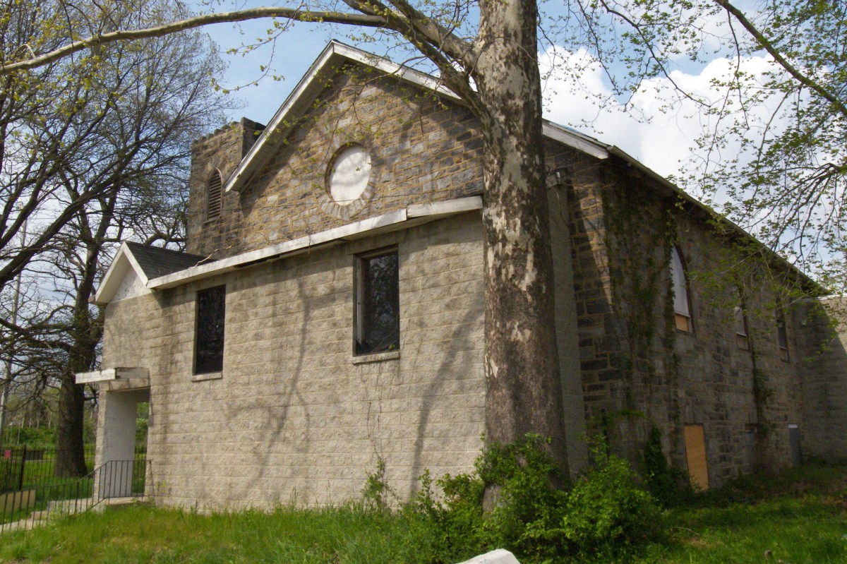
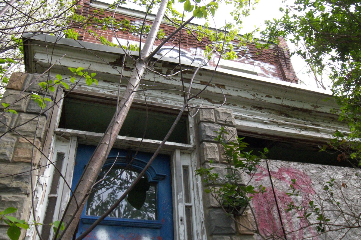
Posters on this site have left comments about idyllic days spent in pre-redevelopment Eastwick. These are some concrete remains of this anomalously interracial community: a church known recently as the St. Paul AME and a two story single-family home on the opposite sides of now-defunct 86th St. and Bartram Ave. Much of the grid system of pre-1950s Eastwick has been obliterated, the untended roads end abruptly or continue into abandoned lowland fields as rutted paths.

Both are located here:

[St. Paul AME Church — in 1942 known as the Eastwick Church, built in 1928 by S.J. Jones]

[Builder’s stone, St. Paul’s AME]

[8608 Bartram Ave.]

More to come.